None
EN
SPC Severe Thunderstorm Watch 547
['Storm Prediction Center']
SPC Forecast Products
Hazard Tornadoes EF2+ Tornadoes Likelihood Low Very Low Severe Wind 65 kt+ Wind Moderate Low Severe Hail 2"+ Hail Low LowNote: The expiration time in the watch graphic is amended if the watch is replaced, cancelled or extended.
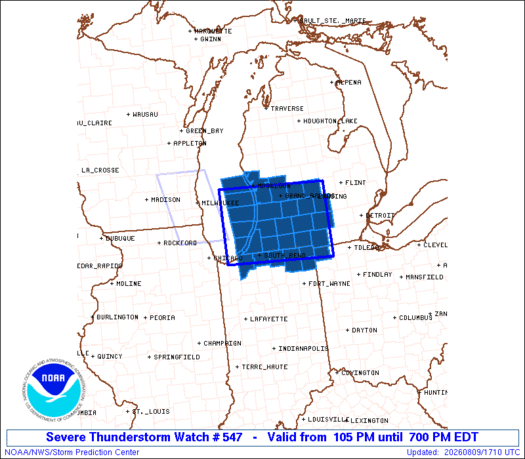
Note: Click forSEL7 URGENT - IMMEDIATE BROADCAST REQUESTED Severe Thunderstorm Watch Number 547 NWS Storm Prediction Center Norman OK 105 PM EDT Sun Aug 9 2026 The NWS Storm Prediction Center has issued a * Severe Thunderstorm Watch for portions of Northern Indiana Southwest Lower Michigan Northwest Ohio Lake Michigan * Effective this Sunday afternoon and evening from 105 PM until 700 PM EDT.
REMEMBER...A Severe Thunderstorm Watch means conditions are favorable for severe thunderstorms in and close to the watch area.
...Hart Click for Watch Status ReportsHazard Tornadoes EF2+ Tornadoes Likelihood Low Very Low Severe Wind 65 kt+ Wind Moderate Low Severe Hail 2"+ Hail Low Low SEL7 URGENT - IMMEDIATE BROADCAST REQUESTED Severe Thunderstorm Watch Number 547 NWS Storm Prediction Center Norman OK 105 PM EDT Sun Aug 9 2026 The NWS Storm Prediction Center has issued a * Severe Thunderstorm Watch for portions of Northern Indiana Southwest Lower Michigan Northwest Ohio Lake Michigan * Effective this Sunday afternoon and evening from 105 PM until 700 PM EDT.
...HartHazard Tornadoes EF2+ Tornadoes Likelihood Low Very Low Severe Wind 65 kt+ Wind Moderate Low Severe Hail 2"+ Hail Low LowNote: Click forWOUS64 KWNS 091701 WOU7 BULLETIN - IMMEDIATE BROADCAST REQUESTED SEVERE THUNDERSTORM WATCH OUTLINE UPDATE FOR WS 547 NWS STORM PREDICTION CENTER NORMAN OK 105 PM EDT SUN AUG 9 2026 SEVERE THUNDERSTORM WATCH 547 IS IN EFFECT UNTIL 700 PM EDT FOR THE FOLLOWING LOCATIONS INC033-039-087-091-113-141-151-092300- /O.NEW.KWNS.SV.A.0547.260809T1705Z-260809T2300Z/ IN .