None
EN
FIRST ALERT: More snow, blistering cold before warmer winter days
[]
WLUC
NWS alerts in effect HERE.
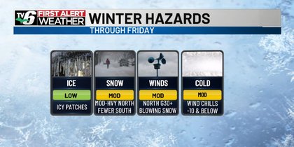
Radar-tracking, hourly forecast plus latest updates>TV6 Apps for iOS and Android devicesA stubborn northwesterly jet continues to bring a bitter brand of cold air to Upper Michigan, plus snow chances by way of passing clipper systems and the lake effect snow machine.
Moderate to heavy snow chances, blowing snow making for periodic travel hazards especially in the Northern U.P.
Breaks from snow, more sunshine this weekend and not as frigid as January draws to a close.
Tonight: Partly to mostly cloudy with scattered snow; moderate to heavy snow chances north; minimum wind chills in the -20s inland; blustery>Lows: -10s to 0s (colder inland)Friday: Mostly cloudy to overcast with scattered snow and areas of blowing snow; moderate to heavy snow chances north; windy>Highs: 0s/10Saturday: Partly cloudy with early morning snow tapering>Highs: 10s/20Sunday, Feb. 1: Partly cloudy before increasing clouds and snow in the evening; breezy; above-average high temperatures>Highs: 20s/30Monday: Mostly cloudy with scattered snow before tapering in the afternoon; patchy blowing snow; breezy and colder>Highs: 10s / 20s EastTuesday: Partly cloudy with few snow showers>Highs: 20sWednesday: Partly cloudy with above-average high temperatures>Highs: 20s/30Thursday: Increasing clouds with scattered snow; blustery>Highs: 20sCopyright 2026 WLUC.